Integration: an instrument for sustainability of urban mobility systems
Value for money in public transit: who is responsible?
Towards a reform of urban transit systems: topics for action
Growing patronage: challenges and what has been found to work
The workshop “Growing patronage: Challenges and what has been found to work” included presentations of 10 papers from all continents, addressing issues including service design, transferability, planning, strategy and decision making. Discussion focused on four topics: conflict or compromise between commercial and social objectives when designing services; the effects of growing demand for car use; which are the most effective instruments to increase patronage recognising that cultural and social differences can also be important contextual biases; and whether the sector is striving for real performance or merely towards contractual compliance, and what has to be done to counteract this trend.
Transferability of sustainable urban mobility measures
This paper describes an approach developed to identify common elements of city performance that have transferability potential across a number of cities. The findings provide a wealth of information sourced from 200 measures in 19 European cities. A transferability framework is proposed, that uses ideas from traditional top-down approaches using city clustering to infer the transferability of measures, as well as elements of a bottom-up approach, based on the concept of “measure enabling context”. Systems’ thinking diagramming was used to depict relationships between measures, drivers and barriers, portraying the feedbacks at work and the cause–effect relationships, to establish appealing preconditions for transferability.
A traffic analysis zone definition: a new methodology and algorithm
This paper develops a comprehensive approach to the definition of transportation analysis zones (TAZ), and therein, presents a new methodology and algorithm for the definition of TAZ embedded in geographic information systems software, improves the base algorithm with several local algorithms, and comprehensively analyses the obtained results. The results obtained are then compared to these presently used in the transportation analysis process of the Lisbon Metropolitan Area. The proposed algorithm presents a new methodology for TAZ design based on a smoothed density surface of geocoded travel demand data. The algorithm aims to minimise the loss of information when moving from a continuous representation of the origin and destination of each trip to their discrete representations through zones, and focuses on the trade-off between the statistical precision, geographical error, and the percentage of intra-zonal trips of the resulting OD matrix. The results for the Lisbon Metropolitan Area case study suggest a significant improvement in OD matrix estimates compared to current transportation analysis practises based on administrative units.
Zoning decisions in transport planning and their impact on the precision of results
In most transport planning studies, one of the first steps is the definition of a zoning scheme into which the study area is divided and the corresponding space is discretized. There are no clear rules on how to carry out this operation in an optimal way, and the dominating practice is to proceed on the basis of experience, trying to mix a certain degree of within-zone homogeneity and the convenience of using administrative borders as zone limits. The potential errors generated with this operation were examined, both at the statistical level when trip matrices are based on sampling and at the geographical level when all trips starting or ending in a zone are assumed to do so at its centroid. A set of quality criteria for a general zoning scheme and an algorithm that constructs a basic zoning on the basis of a sample of geo-referenced trip extreme points and improves it in successive steps according to those criteria are presented. A case study based on the mobility survey for the Lisbon, Portugal, metropolitan area illustrates those steps and the improvements achieved in each step. The magnitude of those improvements is significant and shows that more attention should definitely be given to this initial process in the transport planning studies.
Identifying transit driver preferences for work shift structures: econometric analysis
Transantiago: the fall and rise of a radical public transport intervention
MicroGUTS: un juego de simulación para planificadores de transporte en ambiente microcomputacional
Flexible long range planning using low cost information
Contemporary transport planning requires a flexible modelling approach which can be used to monitor the implementation of a long term plan checking regularly its short term performance with easily available data; the original model is periodically updated using low cost information and this allows the evaluation of the changes to the plan which may be required. Such an approach requires models suited to regular updating and to the use of data from different sources. Models to update trip matrices from traffic counts have been available for some time; however, the estimation and/or updating of other model stages with low cost data has escaped analytical treatment. The paper discusses this idea and formulates the updating problem for an example involving a joint destination/mode choice model under various assumptions about the nature of the available data. Analytical solutions are proposed as well as some general conclusions.
Bus supervision deployment strategies and use of real-time automatic vehicle location for improved bus service reliability
Bus service reliability has long been a top concern for transit agencies and their customers. Improving service reliability, however, has not been easy to accomplish. The use of appropriate recovery times, improved operator training, and better street supervision has produced limited results. Supervision deployment strategies and the use of real-time automatic vehicle location (AVL) information are investigated to improve current supervision practices and enhance bus service reliability. The Chicago (Illinois) Transit Authority’s real-time AVL pilot project for Route 20 Madison is the case study for evaluation of the effectiveness of real-time AVL to improve reliability. A simulation model of the route was developed on the basis of archived AVL data and was used to predict the effects on service reliability when real-time AVL information is used in bus supervision. A week-long experiment was carried out both to verify the model and to address the feasibility and scalability of the system. The main conclusion is that real-time AVL does indeed have great potential to improve service reliability. Service restoration strategies previously impossible to execute are now feasible because of this new information stream. However, many obstacles remain to networkwide implementation, including the supervision communications structure and manpower deployment questions. The flood of information into a central control center must also be addressed. Automation techniques and exception-based reporting are strategies to deal with the problem of information overload.
Road safety in Chile: a short term plan
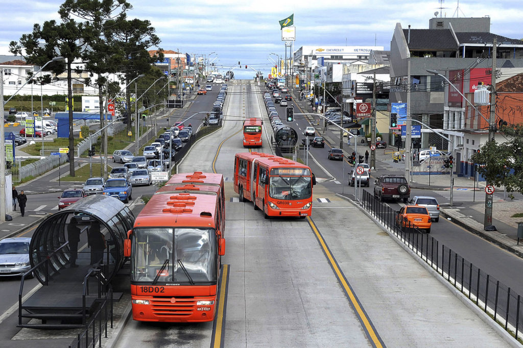
The future of exclusive busways: the Brazilian experience
This paper examines the operation of urban bus transport systems based upon exclusive bus roadways (busways) in three cities in Brazil. The historic, economic, political, regulatory and operating context for these services is discussed. The strengths and weaknesses of busway systems in Curitiba, Porto Allegre and So Paulo are compared, with particular reference to the operating capacity of the busways. The paper concludes with an assessment of the importance of operations techniques, infrastructure development, land use planning, political stability and regulation to the success or failure of these systems.
Urban transport in Australia: has it reached breaking point?
Urban Transport, Environment and Equity: The Case for Developing Countries
Transport metabolism, social diversity and equity: the case of São Paulo, Brazil
The movement of people in space implies the consumption of resources such as time, space, money and energy, as well as the production of negative externalities such as accidents, pollution and congestion. Some of these effects have been analyzed on an aggregate level by comparing regions in the world, a set of selected cities and different geographical areas in a particular city. The analysis of data on a more disaggregate level that considers the differences in the cause and continuance of negative transport externalities among social classes and groups living in a particular city in the developing world is rare.
This paper uses the São Paulo Metropolitan Region (SPMR) 1997 origin–destination (OD) survey to investigate such phenomenon by taking advantage of the fact that data are divided according to six levels of household income. Results refer to mobility patterns in workable days.
The main conclusions are that although people at the lowest income level spend a high share of their income on transport, they have a very low overall mobility and contribute almost nothing to transport externalities. At the other extreme, the two highest income groups that use cars intensively invest much more time, space and money to travel around and so contribute to transport externalities 8.4–15.2 times more than the lowest income group. Such large differences challenge current transport policies in developing countries and call both for a reassessment of assumptions and principles as well as for opposition to the propagation of myths that have sustained such inequitable policies.
The intermittent bus lane signals setting within an area
Intermittent Bus Lane (IBL) used for bus priority is a lane in which the status of a given section changes according to the presence or not of a bus in its spatial domain: when a bus is approaching such a section, the status of that lane is changed to BUS lane, and after the bus moves out of the section, it becomes a normal lane again, open to general traffic. Therefore when bus services are not so frequent, general traffic will not suffer much, and bus priority can still be obtained. This measure can be operating at a single city block, but if all related control parameters along bus lines are considered together, more time gains can be obtained. In this paper, the basic structure and operation of IBL around a single intersection are briefly introduced, then the construction of an objective function and its relationships with the related priority control parameters along one bus line and their simplifications are described. Finally the calculations of the priority control parameters when there are several connected bus lines within an area and some simulation results are discussed.
Involving stakeholders in evaluating transport pricing
Effects of the modifiable areal unit problem on the delineation of traffic analysis zones
Transportation analysis is typically thought of as one kind of spatial analysis. A major point of departure in understanding problems in transportation analysis is the recognition that spatial analysis has some limitations associated with the discretization of space. Among them, modifiable areal units and boundary problems are directly or indirectly related to transportation planning and analysis through the design of traffic analysis zones (TAZs). The modifiable boundary and the scale issues should all be given specific attention during the specification of a TAZ because of the effects these factors exert on statistical and mathematical properties of spatial patterns (ie the modifiable areal unit problem—MAUP). The results obtained from the study of spatial data are not independent of the scale, and the aggregation effects are implicit in the choice of zonal boundaries. The delineation of zonal boundaries of TAZs has a direct impact on the reality and accuracy of the results obtained from transportation forecasting models. In this paper the MAUP effects on the TAZ definition and the transportation demand models are measured and analyzed using different grids (in size and in origin location). This analysis was developed by building an application integrated in commercial GIS software and by using a case study (Lisbon Metropolitan Area) to test its implementabiity and performance. The results reveal the conflict between statistical and geographic precision, and their relationship with the loss of information in the traffic assignment step of the transportation planning models.
The potential impact of automated data collection systems on urban public transport planning
Private sector participation in urban transport infrastructure provision
Estimating a rail passenger trip origin-destination matrix using automatic data collection systems
Automatic data collection (ADC) systems are becoming increasingly common in transit systems throughout the world. Although these ADC systems are often designed to support specific fairly narrow functions, the resulting data can have wide-ranging application, well beyond their design purpose. This article illustrates the potential that ADC systems can provide transit agencies with new rich data sources at low marginal cost, as well as the critical gap between what ADC systems directly offer and what is needed in practice in transit agencies. To close this gap requires data processing and analysis methods with support of technologies such as database management systems (DBMS) and geographic information systems (GIS). This research presents a case study of the automatic fare collection (AFC) system of the Chicago Transit Authority (CTA) rail system and develops a method for inferring rail passenger trip origin-destination (OD) matrices from an origin-only AFC system to replace expensive passenger OD surveys. A software tool is developed to facilitate the method implementation and the results of the application in CTA are reported.
Menghan Li
Yafei Han
Shenhao Wang
Clara Suh